Mountains of Mauritius

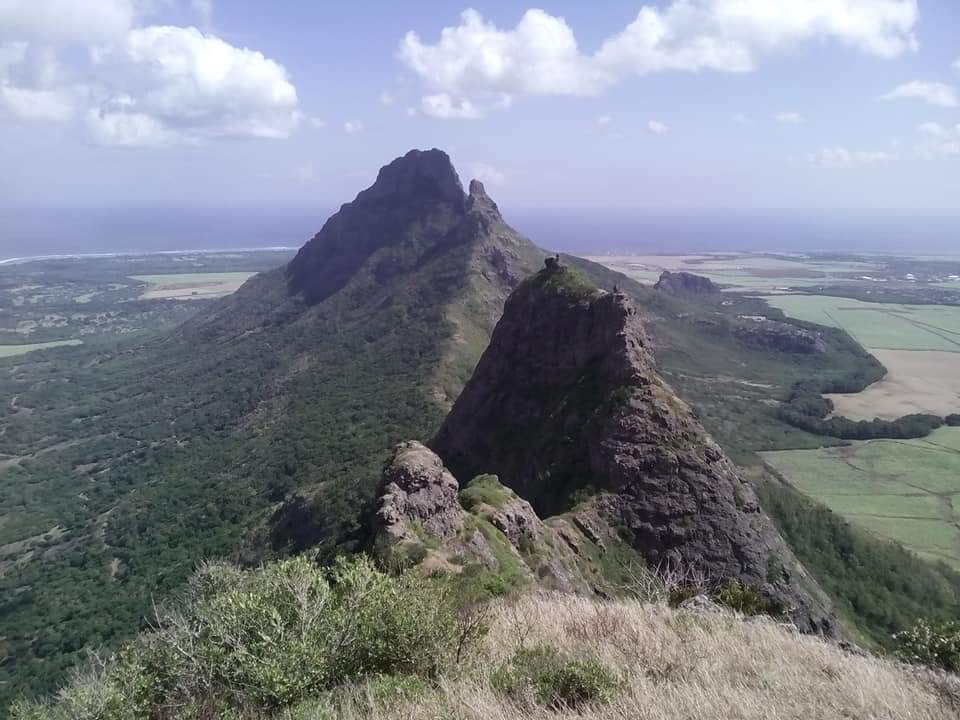
Though Mauritius is characterized as mountainous, it is interesting to note that the area actually classified as ‘mountain’ occupies only 16% (300 km2) of the total surface area of the land. Here, mountains are low; the highest peak, Piton de la Petite Riviere Noire, measures only 828 m. A typical characteristic of the mountains on the island is the steep facade of the inner walls and the gentle spiky nature of the outer walls facing the sea.
Mountain ranges in Mauritius
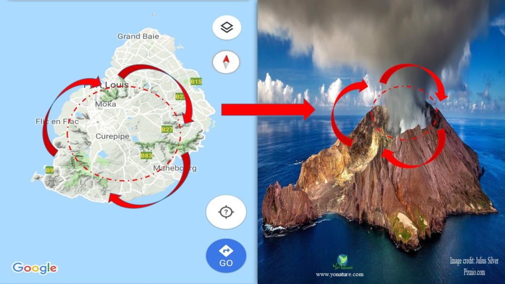
The three mountain belts on the island, Port Louis-Moka Range, Black River-Savanne Range and the Bamboo Range, date to more than 7 million years. They actually represent the remnants of the original caldera of the volcano that formed Mauritius. Notice the particular arc shape of the mountain belts. They are the inner walls of the caldera that spat out the lava to grow the rest of the land.

1. Port Louis – Moka Range
The Port Louis – Moka range consists of two prominent series of peaks. The first alignment consists of Pieter Both (820 m) and Mount Ory (320 m) and the second collateral peaks extend from Snail Rock to Virgin’s Peak. From Pieter Both, the belt sinks into the Deux Mamelles – Calebasses complex and then bulges again into the Nicoliere Mountains arc. The mountain range is actually part of the original volcanic crater as it emerged from the sea during the Breccia series (7-10 million years ago). Climatic conditions, type of volcanic materials and vegetation played a major role in shaping these peaks. Weathering was the chief agent in shaping the slopes; basalt eventually skidded down due to gravity to form talluvium deposits.
2. Black River-Savanne Range
The Black River belt represents the remnants of the main volcanic shield that formed Mauritius. It forms a continuous arc from Mount Rempart to Mount Canon; the highest peak of the island, Piton de la Petite Riviere Noire, 828 m, is located on this range. The mountain massif extends to the south-east to end in the Juracon Spur. A large part of this range is covered in thick olivine basalt from recent eruptions as well as basalt from the old series. The contact between these two lava series can be easily seen at Cascade Chamarel and Cascade Cecile. Magnificent valleys and peaks have resulted in the Black River Gorges as a result of intensive erosion and streamflow.
Geographical studies of this mountain range have presented very useful information about the lagoon formation in the south-west. 18,000 years ago, sea level was 80-85 m lower than what it is today. The flanks of the caldera walls were above sea level and the whole side was exposed then. Soil profiles together with alluvial terraces and floodplains confirm this theory. During sea-level rise and intense precipitation in the Holocene period, sea level rose up to what it is currently and eventually emerged the low lying areas of the volcanic slopes. Lagoon and coral formation was established on the wide eroded materials [1].
3. The Bamboo Range
This thick massif marks the end period of the old volcanic series that created the island; the western border as seen from the east are the fragments of the main Mauritian caldera. Trachytic rock belonging to the first and second stage of the Old Series appear there. The belt extends from Grand River South East to Mount Creoles in the south; the average height of the chain is 525 m. The mountain range is split at two places: Midlands and Eau Bleu. Weathering and erosion are quite active there because of the direction of the winds and the amount of rainfall. Within the range are Mount Fayence and Mount Blanche that gently slope towards the east; the three domes at Trois Ilots are extensions of the Mount Blanche system.
Isolated mountains
A typical characteristic of the mountains on volcanic islands is low rounded hills such as those of Grand Malabar and Petit Malabar. They have been formed as a result of magma that has pushed up inside the land mount but did not actually squeeze out. Steep dykes appeared as a result of vertical magmatic squeezing; peaks also formed during the recent lava flows like the Corps de Garde peak.
Mountain hiking in Mauritius
Mountain hiking in Mauritius is not only a powerful cardio workout but also wonderful entertainment for nature lovers to enjoy some of the island’s native flora and fauna. Breath-taking views of particular portions of the island, towns, coasts, forest and islets can be seen from the mountain tops. While many people hike mountains such as Signal mountain or Dauguet Trail in Port Louis as part of their daily exercising activities, it is recommended to get guides for the remote trails to be on the safe side. No dangerous animals are found on the mountains and it is recommended to use the indicated trails to prevent trampling.
5 best free places for hiking in Mauritius
- Le Pouce Mountain – With the appearance of a thumb, Le Pouce Mountain is an 812 m high mountain found on the Port Louis – Moka range in the north-west of Mauritius. It is one of the most famous and accessible hiking trails that gives a spectacular view of the capital, the highlands and the northern offshore islets.
- Le Morne Brabant Mountain – Found on the south-west of Mauritius, Le Morne Brabant Mountain is an iconic hiking trail of 556 m along which many native shrubs can be seen. The top provides an excellent view of the south-west ocean and lagoon in addition to the illusion of the underwater waterfall.
- Piton de la Petite Riviere Noire – Known as the highest mountain of Mauritius with an elevation of 828 m, Piton de la Petite Riviere Noire is a must-do hiking trail. It is accessible through the western side of the Black River Gorges National Park, thus offering an amazing view of rolling green valleys and hills as well as the south-western coast of the island.
- Lion Mountain – Named as such because of its sphinxlike rocky cliffs, Lion Mountain hiking trail has become very popular in the last years due to its amazing view on the south coast of Mauritius and the offshore islets. The height of the mountain is 480 m and as the trail winds through the peaceful forest, birds like the Mauritius Kestrel can be seen.
- Trois Mamelles Mountain- A little more challenging is the hike to the Trois Mamelles Mountain on the west coast which is sometimes also called the Devil Mountain as the middle peak of the three summits is 666 m high. The slopes are a bit rugged and may require the use of hands to ascend yet worth the splendid view on the western coast.
Mountain climbing in Mauritius
Conversely to hiking which is walking through vegetation and greenery to mountain summits or along the flanks, mountain climbing requires safety equipment and knowledge of the surroundings. Given the topology, climate and age of the island, there are not many harnessed mountain climbing opportunities, yet the few are thrillers for the more adventurous. Private tour agencies propose mountain climbing packages to some sites in Mauritius.
3 best places for mountain climbing in Mauritius
- Pieter Both Mountain – Basically this climb is for the lionhearted ones as it consists of ascending a boulder that stands on equilibrium on the summit of the mountain. The hiking trail is somewhat steep and requires ease to heights.
- Rempart Mountain – Found on the west coast of Mauritius, Rempart Mountain presents a fantastic experience for the advanced climbers. The hike through the vegetation and sugarcane fields is quite simple but climbing the steep walls is quite challenging.
- Black River Peak – The peak of the Black River is totally worth the effort as it gives a bird’s view of the lush valleys and hills, the offshore islets and a panoramic view of the whole island. The trail to the summit is quite steep but not difficult.
Reference:
- Saddul, P. (2002). Mauritius, A Geomorphological Analysis. Moka, Mauritius: MGI, pp 84

Pingback: Effects of landslides: Positive, Negative, Examples - Yo Nature
Pingback: The forests of Mauritius - Yo Nature
Pingback: Unbelievable but true - Underwater waterfall in Mauritius! - Yo Nature
Pingback: Valleys on planet Mars resemble amphitheater valleys on Earth - Yo Nature