
The forests of Mauritius
Gentle slopes with lush green forests interrupted now and then by meandering streams; lazy animals crawling under the thick shady ebony trees or enjoying the sun on the spotlessly white sand. This was tropical life for many creatures on the island of Mauritius before it was discovered by the Portuguese in 1507. Once man set foot on the island, massive deforestation began.
Brief history of deforestation in Mauritius
Though the island of Mauritius was already recorded on charts since 1501 [1], it was during the 1600s that felling of trees started. Navigators stopped by the island to cut down the coveted ebony trees, famous for its high quality and resistance. With colonisation of the island by the Dutch in 1639, ebony trees were cut en masse for exportation. Eventually, agricultural development started with the introduction of the Java sugarcane from Java, Indonesia. Land was cleared for this purpose but the project did not go through. Discouraged by the hardships that they were facing on the island, the Dutch left a mutilated Mauritius. During the 1700s, under the governor Mahe de Labourdonnais, clearing of forests resumed giving way to settlement and development. In 1835, Major Mackenzie Fraser drew a map of Mauritius showing that two-thirds of the island had still been left untouched.
The original flora of Mauritius
Early records of the floral canopy include the following: [2]
- Trees’ heights were on average 24 m but rarely exceeding 30 m, with diameters in the 0.9 m to 1.2 m;
- Leaves were as thick as leather;
- Underwood of different tree species formed a secondary forest under the taller trees;
- Lianas and climbers span from one level of trees to another;
- Epiphytes and tree ferns added to the beauty of the stunning canopy.
Common trees then were the Tambalacoque, Makak, Colophane, Natte, Sandal, Tatamaka, Pomme, Olive and Cannelle in the humid regions. Dry places were mostly dominated by Ebony, Benjoin and Puant. Lower canopy species included the Sagaye, Ronde, Fer, Lousteau and Clou amongst others.
The Great forest destruction
It was in 1864 that mass forest clearance occurred to lay down railway tracks. The peak of deforestation culminated in 1871-72. Though there was a revolt against it then, blind eyes were turned to the situation until the works were forced to stop in 1875 where only mountain flanks and river banks were spared. The situation became alarming as tree removal affected the water supply directly. As of 1880, only 3,568 acres of shabby virgin forest remained and an officer from India, Mr R. Thompson, was positioned to help repair the damage. He laid out plans for afforestation in particular places so as to secure water supplies for the British colony. Reconditioning of the natural woodland began and an additional 30, 200 acres of forest was planted. But the regeneration of species was greatly halted by
- the open areas which did not provide adequate environmental conditions for seeds to grow,
- the death of seeds due to extreme conditions,
- introduction of vigorous invasive plant species which competed with native ones and hindered their development and
- the introduction of alien animals that fed on seedlings and destroyed them.
Mauritius is known worldwide for the devastating deforestation that occurred during that time period. It has been the subject of interest of numerous individuals; one of them, Mr A. Walter, concluded that deforestation led to a significant decrease of rainy days in the south-eastern coast where destruction was more intense. It is believed more than 100 species of plants and animals became extinct as a result of human settlement on Mauritius.
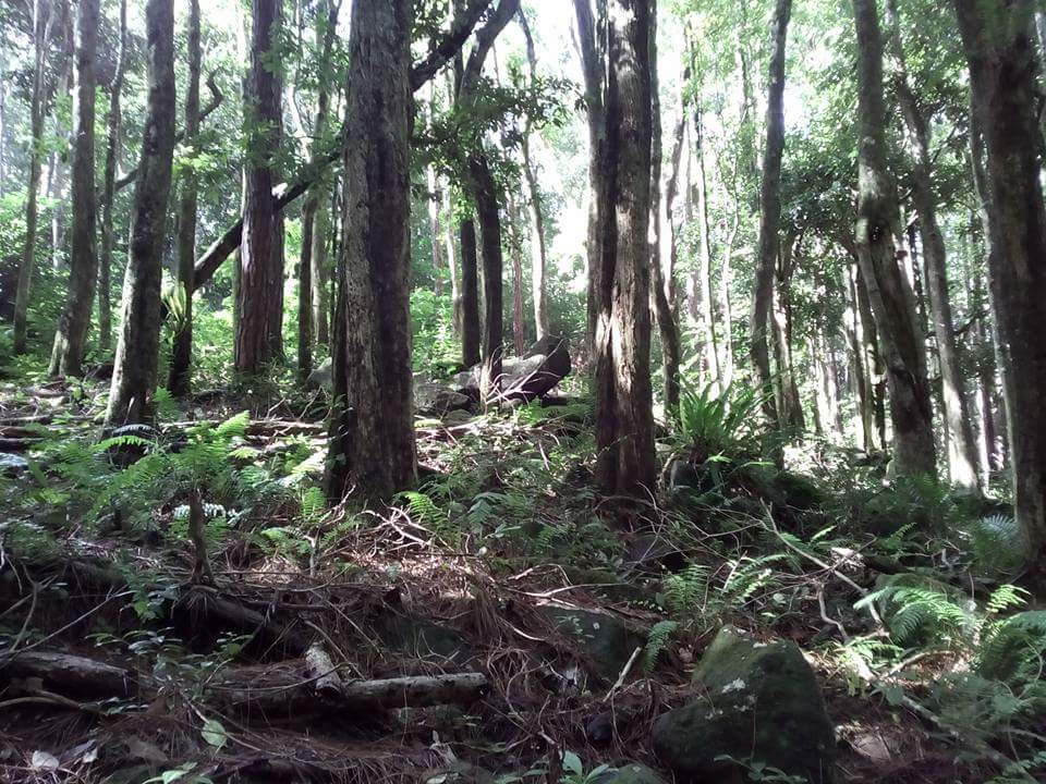
The status of Mauritius forest today
At present there are only 139,000 acres of forested land on the island; of the original pristine forest, less than 2% remains. Most of the forest areas now are replanted sites or have been turned into deer ranches or got degraded and invaded by alien species. 47% of the forest land is state-owned and includes nature reserves, national parks, pas geometriques and plantations [3] on the coasts, offshore islets and mountain flanks, while the remaining 53% is privately owned. 691 species of native trees still exist with 150 Mascarene endemics and 273 island endemics while only some native birds, reptiles and one bat species still live in the forest.
Where can the native forest be seen?
Unlike replanted forest strips scattered all over the island, native forests give a glimpse of what the island really looked like before colonization. Most of the native forest in Mauritius border the mountain ranges, isolated mountains and the offshore islets. In terms of districts, highly forested regions per surface area are Plaines Wilhems (the highlands, 31%), Port Louis (mountains, 24%) and Savanne (mountains, 20%). Native shrub-dominated regions include Black River (Black River Georges National Park, 58%), Port Louis (mountains, 43%) and Moka (mountains, 34%).
Native trees of Mauritius
Some of the endemic trees that are only found in Mauritius include the Bois Jaune (Ochrosia borbonica) at Bel Ombre, Bois d’ebene marble (Diospyros egrettarum) on Ile aux Aigrettes, Figuier Blanc (Ficus laterifolia) at the Curepipe Nursery, Bois de clous (Eugenia hastilis) at Bras D’eau, Bois de pomme (Syzygium contractum) at Mountain Lagrave, Bois de perroquet (Olax psittacorum) in the dense forest of Bois Cheri and Quartier Militaire, Palmiste marron (Latania loddigestii) on Round Island, Bois de catafaille noir (Zanthoxylum heterophylum) in the coastal forest at Brise Fer, Bois matelot (Souriana maritima) on Flat Island and Manglier vert (Sideroxylon cinereum) which is commonly found on the island.
Best hiking and trekking trails in Mauritius
Given the hilly nature of the island, forest trekking and hiking is a worthwhile activity that offers different panoramic views of Mauritius depending on the location. For safety reasons, it is advised to trek or hike in groups and to be accompanied by guides on off the beaten tracks. There are no dangerous animals in the forests of Mauritius, mostly monkeys, hares, boars, birds, mongooses, bats and geckos. Chunks of forest areas can be seen at the national parks on the mainland and the offshore islets as well as in several payable privately owned reserves.
5 best free forest trekking and hiking trails
- Black River Gorges National Park: By far the best forest trekking experience is the Black River Gorges National Park in the south-west that is home to several native trees, endemic birds like the Pink Pigeon and Kestrel, waterfalls, water pools and presents scenic views of the island.
- Bras d’eau National Park: The Bras d’eau National Park on the northeast still contains some of the past relics like sugar mills and railways amidst luxurious trees and is an ideal site for bird watching.
- Le Pouce mountain: Loved by locals, hiking Le Pouce mountain to the top gives a wonderful view of the capital, Port Louis, the mountains along this mountain range and if the weather permits, the offshore northern islets.
- La Nicoliere reservoir: Located on the northeast, La Nicoliere reservoir is a small lake that provides water to people in the north and the capital. It is a well-frequented forest trail because of the quietness that surrounds the region to the small reservoir.
- Le Morne Brabant Mountain: Hiking Le Morne Brabant Mountain in the south-west is a must-do activity as it represents one of the most important cultural roots of Mauritius. Declared as a UNESCO World Heritage Site in 2008, it is the place where slaves used to come and jump into the sea to escape from their masters in the old days. A number of native shrubs can be seen along the way and the beautiful illusion of the underwater waterfall can be spotted from the top.
Caution during forest trekking and hiking
- Bring your own food and water.
- Bring a mosquito repellent.
- Wear hiking shoes.
- Be cautious of the spines on shrubs.
- Check the weather as muddy trails make mountain hiking dangerous.
- Get your Google map and camera; keep camera sound low so as not to disturb birds.
- Walk on the trails to prevent trampling, do not litter and scare animals.
References:
- Toorawa, S. (2007). The medieval Waqwaq islands and the Mascarenes. Port Louis, Mauritius: Hassam Toorawa Trust.
- Macmillan, A. (2000). Mauritius Illustrated: Historical and Descriptive, Commercial and Industrial, Facts, figures and Resources. New Delhi, Madras, India: Asian Educational Services, pp 103
- National Parks and Conservation Services. Forest and Terrestrial Biodiversity of Mauritius. [pdf] Available at http://npcs.govmu.org/English/Documents/Chapter%202-4.pdf [Accessed 09.03.2018]
Pingback: Mauritius: Geography, History, Travel and Top Attractions - Yo Nature
Pingback: Dodo Bird of Mauritius: From Discovery to Extinction - Yo Nature
Pingback: Monkey Trade in Mauritius: Controversies and Benefits - Yo Nature
Pingback: Offshore islets of Mauritius: National Parks and Nature Reserves - Yo Nature
Pingback: Biodiversity (Flora and Fauna) of Mauritius - Yo Nature
Pingback: Jackfruit – Don’t judge by the smell! - Yo Nature
Pingback: The negative impacts of humans on the environment - Yo Nature
Pingback: Why islands must protect their mangrove forests - Yo Nature