
Earthquakes Explained: Types, Causes and Examples
Earthquakes are hazards that can cause a lot of damage. Sometimes they devastate regions right where the quake starts. At other times, they have severe repercussions far away from the point of initiation. On average, some 10,000 people die every year due to earthquakes and economic losses are in the billions of dollars. The Tohoku Earthquake that hit Japan in 2011 released some 600 million times more energy than the atomic bomb released on Hiroshima.
What is an earthquake?
An earthquake is manifested as the shaking of the ground. The sudden release of energy throughout the Earth’s crust causes it. Various natural and man-made causes may trigger this energy release. Volcanic eruptions and plate tectonic processes are examples of natural sources. Manmade causes of earthquakes include excavation of mines and explosions.
What happens during an earthquake?
Basically, the earthquake cycle explains earthquake events. It proposes that there is a drop in elastic strain after an earthquake and an increase in strain before the next one.
Strain refers to deformation resulting from stress (pressure exerted on a material). Elastic strain is temporary deformation as the stress is eventually released. Thus, the material returns back to its original shape. If not, the deformed material just ruptures.
When rocks along faults are stressed, the rocks deform elastically. If the stress is less than the rocks can support, the rocks return back to their original state. If the stress is too much, the rocks rupture releasing energy in the form of seismic waves.
Theses waves propagate in the surrounding regions and are perceived as ground shaking or earthquakes. The epicentre is the place on the surface of the Earth where the rocks rupture to produce the earthquake. The focus or the hypocenter is the point of rock breaking within the Earth and is directly under the epicentre. When a fracture starts, rocks scatter from the focus, moving up, down and laterally along the fault plane. The sharp rupture of rocks produces the seismic waves leading to ground shaking.
Why do earthquakes occur?
Earthquakes occur due to various natural processes as well as man–made ones.
Natural causes of earthquakes include
- Tectonic movement
- Atmospheric pressure changes
- Migration of fluids in the crust of Earth
- Surface ice and snow loading
- Tides
- Heavy rainfall
- Sediment unloading
- Groundwater loss
In most of these above-mentioned cases, stress on faults is only in small amounts. Thus, these types of earthquakes are barely felt.
Manmade causes of earthquakes include
- Mining activities
- Constructing reservoirs/dams
- Erecting tall buildings
- Engineering coastal sediments
- Quarrying
- Extracting groundwater
- Mining
- Excavating tunnels
- Producing hydrocarbons
- Producing geothermal energy
- Injecting fluids into the ground (military waste, wastewater)
- Explosions
The strength of evidence for these types of earthquakes varies a lot between cases. But what is certain is that intense activities like mining positively impact on earthquake generation.
Most common types of earthquakes
Nevertheless, four types of earthquakes are most common. These are due to
- Fault ruptures
- Volcanic activities
- Construction of large reservoirs and
- Mining activities
Earthquakes due to fault ruptures
The most common type of earthquake that occurs is the fault rupture-induced as a consequence of plate movement. Here, the theory of plate tectonics explains these earthquake events. The plate tectonics theory was put forward by the Canadian geophysicist, John Tuzo Wilson in 1965. It is based on the theories of continental drift by Alfred Wegener (1915) and seafloor spreading by Harry Hess (late 1960s).
Plate Tectonic Theory
As it is, Earth is divided into three main parts: the outer crust, the middle mantle and the inner core. John Tuzo Wilson stated that Earth’s crust (lithosphere) is split into large, rigid rock slabs called ‘plates’. These plates are about 100 km thick. They float atop the asthenosphere, an underlying rock layer that is softer and warmer and thus viscous in nature. The lithosphere moves horizontally on the asthenosphere at a velocity of 1 to 10 cm per year due to convection currents in the mantle. Consequently, plate movement can be tracked today using technological tools. These include Global Positioning Systems, satellite laser ranging and very long baseline interferometry.
As the plates move on the asthenosphere, tectonic forces take place at their edges. These forces cause physical and chemical changes in the plates thus affecting their geology. Since there are some rigid and fragile spots on the crust, tectonic movement can cause fractures that result in earthquakes.
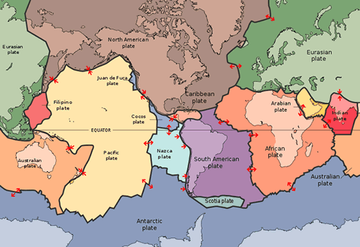
Photo by Blatant World from Flicker
Earthquakes along plate boundaries
Wilson declared that there are three types of plate boundaries: divergent, convergent and transform boundaries.
Earthquakes at divergent plate boundaries
Divergent plate boundaries refer to margins where plates separate from each other.
Narrow bands of shallow earthquakes that are moderate in magnitude occur along divergent plate boundaries at mid-ocean ridges. As the plates separate, the crust cracks forming faults. When strain becomes excessive along the fault, the rocks rupture and release energy: earthquakes thus result.
Examples of earthquake-prone regions along divergent boundaries are the Azores and Iceland. This is because they lie on the Mid-Atlantic Ridge. The Mid-Atlantic Ridge is a mountain range on the seafloor that has numerous transform faults as well as a rift valley. This ridge separates the North American Plate from the Eurasian Plate in North Atlantic. It also divides the South American Plate from the African Plate in South Atlantic.
Earthquakes at convergent plate boundaries
Convergent plate boundaries are margins where plates move towards each other.
Here, shallow to intermediate earthquakes take place in bands of hundreds of kilometres wide.
Sometimes, when plates converge, one plate can move underneath the other one. During this process called subduction, there is high straining and fracturing of the crust. This results in surface brittle ruptures together with frictional slip within cracks. As strain reduces, seismic energy in the form of an earthquake escapes. In fact, continental convergence earthquakes can be very large.
Examples of regions that face earthquakes due to convergent plate boundaries are the Caribbean and Central America. Here, on the one hand, the Cocos Plate subducts under the North American and Caribbean Plates. On the other hand, the North and South American Plates subduct under the Caribbean Plate.
Earthquakes at transform plate boundaries
Transform plate boundaries are those edges along which plates slide past each other.
In this case, shallow earthquakes but with large magnitude take place along transform faults (fractures). As the plates move past each other, friction along the boundary may slow their motion. But, rough edges may also break off with motion prevailing at several places. This motion stresses rocks along the fault causing them to strain. When the strain becomes too much, the rocks rupture and shift releasing energy. This results in earthquakes.
California illustrates clearly a region that faces earthquakes due to transform boundaries. This is because it is located on the San Andreas Fault which is the boundary of the Pacific and North American Plates.
Intraplate earthquakes
While most of the time earthquakes take place on plate boundaries, sometimes they can also occur anywhere on the tectonic plates. Geologically, this shows that the crust is not rigid and internal fractures can occur. Seismic activity leading to earthquakes in these regions is attributed to geological complexity or temperature and strength differences.
These types of earthquakes can cause considerable damage when populations are unprepared for them. For instance, in the winter of 1811-1812, two such earthquakes shook the central Mississippi Valley. They nearly destroyed the town of New Madrid, Missouri, and was felt as far away as Canada.
Earthquakes related to volcanic activities
Another important source of earthquakes is related to volcanic activities. When there is a change in the stress state of solid rocks inside a volcano earthquakes result. This can be in the form of magma withdrawal or injection.
Thus, when there is no more magma in certain spaces inside a volcano, rocks take its place. As the rocks topple, tremors reverberate in the form of earthquakes.
Conversely, magma can also fill the surrounding rocks. This results in pressure changes during the transport of magma leading to ground shaking. As these vibrations are sustained, several earthquakes kick off. Interestingly, this type of activity also indicates that the volcano is about to erupt.
Reservoir construction-related earthquakes
When people construct deep and large reservoirs or create dams to store water, earthquakes can occur. This happens because of the enormous weight that the stored water has on the ground. It creates or extends fractures in the surrounding rocks and increases pressure in the adjacent regions. As a result, new faults emerge or existing ones start off, therefore, causing earthquakes. In India and China, for example, numerous earthquakes greater than 6.0 in magnitude have occurred due to the creation of reservoirs. Many people have died as a consequence and the reservoirs themselves have been damaged.
Earthquakes due to mining
Mining activities relate to the extraction of valuable materials from the surface of the Earth. This type of activity is well known for its seismic events. Mining impacts on the stress state of the surrounding rocks. These stress differences can exceed the strength of the rocks initiating earthquakes. In South Africa for instance, mining-induced earthquakes frequently occur. This is due to the extraction of gold and platinum from the ground.
How to measure earthquakes
The size of an earthquake is expressed in many ways. But basically, earthquakes are measured based on their intensity and magnitude.
Intensity
The intensity of an earthquake refers to a measure of damage to structures, surface effects and human reactions to that earthquake tremor. It is a subjective metric to evaluate the amount of damage caused. This harm is related to human populations, familiarity with earthquakes and construction types. Generally, scales like the Modified Mercalli Scale measure the intensity of an earthquake.
Magnitude
Conversely, magnitude is a measure of earthquake size and fault dimensions. It is based on the maximum amplitudes of seismic waves and as such is an important objective scale. The Richter Scale is the most common type of scale to measure the magnitude of earthquakes.
Where do earthquakes occur?
Earthquakes usually take place at depth of several tens of kilometres with some occasionally up to several hundred kilometres deep. Earthquakes occur most frequently along seismic belts, that is, plate boundaries. The regions that are the most seismically active are the Circum-Pacific Belt and the Eurasian or Alpine Belt. Consequently, countries and islands that are close to these belts are subject to earthquakes.
Countries on the Circum-Pacific Belt
New Zealand, New Guinea, Philippines, Japan, the Aleutians Islands and the west coasts of North America and South America lie on the Circum-Pacific Belt. The 1995 Kobe Earthquake that took place in Japan occurred along the Circum-Pacific Belt.
Countries on the Alpine Belt
Territories found on the Alpine Belt include the northern part of the Mediterranean Sea, central Asia, southern Himalayas and Indonesia. The devastating 2004 Indian Ocean Earthquake and tsunami episode that killed some 250,000 people occurred on the Alpine Belt.
References
- Keller, E. and DeVecchio, D., 2015. Natural hazards: earth’s processes as hazards, disasters, and catastrophes. Pearson Higher Education AU.
- Elnashai, A.S. and Di Sarno, L., 2008. Fundamentals of earthquake engineering (p. 34). New York: Wiley.
- Foulger, G.R., Wilson, M.P., Gluyas, J.G., Julian, B.R. and Davies, R.J., 2018. Global review of human-induced earthquakes. Earth-Science Reviews, 178, pp.438-514.
Pingback: Volcanic Eruptions Explained: Types and Examples - Yo Nature
Pingback: Droughts Explained: Types, Causes and Examples - Yo Nature
Pingback: Wildfires Explained: Types, Causes and Examples - Yo Nature
Pingback: Flooding Explained: Types, Causes and Examples - Yo Nature
Pingback: Tsunamis Explained: Types, Causes and Examples - Yo Nature
Pingback: Effects of Earthquakes: Positive, Negative, Examples - Yo Nature